WX99 · Certification — Marine Weather Part 1
73 questions · 67 multiple choice · 6 written · ASA 109 Marine Weather — Final Certification (Part 1, mostly MC + a few written)
Correct answer is all are the same. mb = hPa, and these are all the same value of the standard atmosphere pressure.
AI answer
💡 Show hint
One of the most fundamental definitions in marine weather.
Shifted to the left so it has backed. In modern usage, this does not depend on hemisphere.
AI answer
Oregon, or at times any state on the West Coast. Sea breeze is any wind coming from the sea — more specifically from any region that has more water into a region that has less water.
AI answer
National Data Buoy Center. All data are online for easy access or can be reached by cell phone or satellite phone.
AI answer
Knots = 1.94 × m/s
AI answer
Reference answer
AI grading
AI answer
💡 Show hint
Isobars (lines of constant atmospheric pressure) are drawn at constant pressure intervals across the map and the same interval is used on all maps. For U.S. maps the interval is 4 mb (occasionally with dashed lines at 2 mb).
Widely spaced isobars mean the pressure drops slowly across them, so the pressure gradient force is small and the wind is weak. A spacing of 300 miles is wide; 60 miles is close. Sky cover and precipitation cannot be inferred from isobar spacing alone.
AI answer
Can't say from this alone. At any one place, even the summer/winter averages can vary as much as the spread shown here. Check US Coast Pilot, Meteorological Tables, Pilot Charts, or Climate Forecast System model predictions out to 6 months.
AI answer
💡 Show hint
Official definition used consistently. Recall what they call this pressure change.
Pressure tendency is always given over the past 3 hours. e.g. if pressure now is 1024 and 3 hours ago was 1022, the tendency is +2 mb.
AI answer
💡 Show hint
Draw the wind circulation around a Low and place an observer at the proper place to get a northwest wind.
Buys Ballot's law (NH): with your back to the surface wind, put your left arm out and slightly forward (10–30°); it points toward the center of the low (or, more precisely, in the direction of decreasing pressure).
AI answer
💡 Show hint
Every vessel at sea has one, but are they really used effectively?
The barometer is a crucial instrument and you get most out of it with practice and calibration. But even an uncalibrated instrument is useful for detecting pressure CHANGES — what matters most for forecasting. Place it near the nav station for easy frequent reading.
AI answer
💡 Show hint
When fronts are associated with Lows, the severity of the front is often correlated with the severity (depth) of the Low — but not always.
Lows generally reach peak depth as their fronts occlude — the occlusion process cuts off the source of warm moist air which is the storm's fuel. The Low begins to dissipate after.
AI answer
💡 Show hint
A consistent pressure drop with time is a clear warning to look into what's causing it. A cyclonic Low generally brings bad weather with it.
All listed factors can contribute. In practice the Low moving across you is usually the biggest contributor. Watch for a steady drop lasting at least two 3-hour periods. "Meteorological bombs" deepen ~24 mb in 24 h.
AI answer
💡 Show hint
Consider the vertical motion of air. "Bad" weather means strong winds, clouds, and rain. The key phrase is "replacing good."
Falling pressure. Steady usually means no change; rising pressure usually means improving weather (with rare exceptions like a bent-back occlusion). Wind speed depends on the gradient, not the direction of change.
AI answer
All we know is the true wind is aft of the apparent wind, so 070R is the only solution. 310R is 50° on the port side, which is not possible.
AI answer
💡 Show hint
If needed, sketch a high or low and draw in the winds.
15° to 30° across the isobars, into the low and out of the high.
AI answer
💡 Show hint
Global wind, not local. Horse latitudes are Highs, doldrums are Lows.
See trade winds, horse latitudes, and doldrums; the global wind belts in the World Atlas explain the pattern.
AI answer
💡 Show hint
Both of these properties can directly affect what we experience on the surface.
Temperature drops about 4°F per 1,000 ft and the wind veers (over the first ~2,000 ft, total veer 10–40°).
AI answer
Stratiform — stable air produces flat layered clouds. See section 3.4 on stability.
AI answer
💡 Show hint
Often described as an "effect" of the earth's rotation rather than the result of an actual force, but fundamental to global wind and ocean circulation.
See Coriolis force; discussed in detail in Chapter 2 on wind.
AI answer
Because there are intervening land masses interrupting the corresponding latitude range in the Northern Hemisphere that are not present in the Southern Hemisphere.
AI answer
💡 Show hint
Assume the actual sea state is about the same on each side; there are just more white caps on one side.
Get into the white caps — they mark an area with current going with you. Current flowing into the wind makes notably steeper waves that break more often.
AI answer
Heated air rises at the equator and is forced poleward; Coriolis bends the wind to the right (NH), setting up rivers of strong eastward winds aloft. These are the steering winds that move surface patterns to the east.
AI answer
💡 Show hint
Air masses are named after their properties which reflect their origins. Know what c, m, T, and P stand for.
Warm moist air is called maritime tropic. See trade winds and air-mass classification.
AI answer
In the NH, squalls move in a direction veered from the ambient surface winds because they are driven by the higher (veered) winds aloft.
AI answer
80°F is the accepted value based on research cited in the course materials.
AI answer
Strong winds come with the initial downburst, which brings the rain and wind together. See Chapter 4 on squalls.
AI answer
💡 Show hint
The answer is different on land.
Squalls need a vertical updraft to start formation. Over warm waters typical of frequent squalls, daytime air can be cooler than the water; at night the warmer near-surface air starts to rise — these are 'air-mass' thunderstorms and they're more likely at night than in the afternoon.
AI answer
Wind builds as the front approaches, suddenly veers at the frontal surface, then remains more or less steady as the warm sector passes. (West Coast wind often backs as it builds; East Coast is less consistent.)
AI answer
Cold front: short heavy rain, cumulonimbus, larger veer. Warm front: long light rains, stratus clouds, smaller veer.
AI answer
34 to 47 kt. There are different historical gale classifications, but they are rarely used these days. The NWS glossary is online.
AI answer
💡 Show hint
Doesn't say what hurricane zone. With these choices, does that matter?
See Chapter 4 or the NHC website. Peak season is easy to specify, even though start/end dates are less consistent.
AI answer
💡 Show hint
Valuable to know there are two sides AND why, plus the full range of differences between them.
All points are true, but the direction of the wind into the storm's path is the most important.
AI answer
💡 Show hint
A frontal system has a warm front (leading edge of warm air), then the warm sector itself, then the cold front. Each zone has distinctly different weather.
Isobars in the warm sector are usually straight and evenly spaced (steady wind), and the entire frontal system tends to move parallel to those isobars.
AI answer
Secondary lows often develop more intense than the primary that created them. Secondaries can also form at the tip of the occlusion once it forms.
AI answer
💡 Show hint
Not a lot of whitecaps — just a few if you look carefully.
In still water ~10 kt; with a knot or more of current with the wind, ~12 kt; with current against the wind, ~8 kt. Use the effect in reverse to read the surface for current direction.
AI answer
About one day. Rough rule: hours of wind needed for full development ≈ wind speed in knots (for winds < 30 kt). 25 kt → ~25 h ≈ 1 day.
AI answer
Significant Wave Height (SWH) = the average of the highest one-third of all waves. Universal definition.
AI answer
Trade-wind belt has the largest waves because the fetch and stability of the wind are very high. The other listed systems have very short fetches.
AI answer
Classic warm-front approach: backing wind followed by a veer. Helpful rule: the time from the first signs of the front until rain starts is roughly how long it will rain until the front passes.
AI answer
Winds at cumulus cloud level are veered 10–30° from surface winds over water (more over land), so they appear from the right of the true surface wind by that amount.
AI answer
High pressure is descending air that evaporates the clouds. This could in principle be stable or unstable air.
AI answer
💡 Show hint
If the wind on the beach is northeast, what direction would you expect it to be some distance out into the water?
Less friction aloft means wind veers as you go up. Land has more friction than water, so wind backs going from sea to land. Going from land out to water it veers (absent other factors).
AI answer
💡 Show hint
Have you ever pulled in from sailing in one breeze, tied up the boat, and noticed that the wind ashore is dramatically different?
The key is friction: land has lots, water has much less. Excluding channeled effects, wind on the water is always stronger than nearby land. Factor of 2 is a reasonable working rule.
AI answer
Sea breeze is the most common land effect on coastal wind, but it is rarely a hazard by itself. Only when channeled does it become dangerous (gap wind).
AI answer
💡 Show hint
Northern Hemisphere general case.
Sea breezes are usually the resultant of a developing thermal wind and an existing gradient wind. In the NH the building thermal part will veer as it develops (descending from less-friction air aloft).
AI answer
💡 Show hint
The usual case in clear skies throughout the world during late afternoon.
See sea breeze in Chapter 6 on wind and terrain.
AI answer
Sea breeze is the most common, but gap or channeled winds are usually the source of the strong winds.
AI answer
Sea breezes exist on almost all near-coastal waters to some extent.
AI answer
💡 Show hint
Northern Hemisphere — it does matter.
More from the southeast — sea breezes in the Northern Hemisphere veer as they build (and back in the SH).
AI answer
8 times the height. A standard rule of thumb for staying out of the wind shadow of an elevated obstacle.
AI answer
💡 Show hint
Some maps use a different convention which simplifies this issue, but many worldwide do not. Note labels could also be even numbers like 564.
See 500-mb maps. Winds aloft flow along the contours of the 500-mb surface — where the contour is steep, the wind is faster.
AI answer
Reference answer
AI grading
AI answer
💡 Show hint
Is there a difference between coastal maps and offshore maps? See Caption to Figure 2.2-3.
Reference answer
AI grading
AI answer
Tropical-storm-force at 34 kt. Since 34 > 32.5 it is plotted with 4 feathers (3 long, 1 short). See https://ocean.weather.gov/UsersGuide/UGprint.php (33 kt at 48 h, 34 kt at 96 h).
AI answer
Coast Pilot is the best starting point for US inland or coastal waters.
AI answer
💡 Show hint
See textbook Section 4.6.
Simulated Radar Reflectivity. See textbook.
AI answer
Pilot chart — useful for both a quick look at High locations and for specific wind probabilities.
AI answer
All provide the data. Bowditch is a quick lookup; Mariners Weather Log includes extra-tropical and tropical storms summarized by quarter; the NHC is the most comprehensive. The Starpath Weather Trainer software also presents this data clearly.
AI answer
Reference answer
AI grading
AI answer
NOAA weather radio… at least for a year or so, then all bets are off.
AI answer
To prevent getting caught in a hurricane, avoid the areas the NHC forecasts having winds of 34 kt or more. They are plotted on the Tropical Cyclone Danger Maps (textbook Figure 8.7-7).
AI answer
All listed indicators can be the most useful indicator of strongest current flow. See text on Gulf Stream plus Forum discussion.
AI answer
💡 Show hint
Not the passage of the low itself, but its approach — maybe 12 to 24 hours before.
The actual rate of pressure drop depends on many factors. The given answer comes from averaging many published barograph traces of severe lows — this is the initial down-turn 12–24 h before the low arrives, NOT the rate at the low itself (which is much steeper, 6–10 mb per 3 h).
AI answer
💡 Show hint
All are signs of possibility of poor weather. One is better than the rest — especially in summer.
A ring around the sun or moon is the most positive sign — it proves a transparent layer of cirrostratus has been forced over you by an approaching warm front, usually the first step in an approaching mid-latitude Low.
AI answer
💡 Show hint
Things we can see or measure from the boat. Applies to all latitudes/hemispheres.
A long low swell would likely be the first sign, especially in tropical waters as an indicator of a tropical cyclone. See sea state and forecasting tips.
AI answer
💡 Show hint
Assume normal conditions for a building sea breeze are all present, it just isn't there.
Sea breeze comes from land heating more than nearby water (creating a low over land, high over water). If an offshore Low approaches at the same time, the reduced pressure on its fringes can cancel out the land-water differential and kill the sea breeze. Same logic if a fresh sea breeze fades early in the afternoon.
AI answer
💡 Show hint
The speed of sound in air is about 331 meters per second.
Using the units converter, 331 m/s ≈ 740 mph and 20 s ≈ 0.0056 h, so 740 × 0.0056 ≈ 4.1 miles. Equivalently, every ~5 seconds of delay between flash and thunder ≈ 1 mile.
AI answer
💡 Show hint
A fundamental part of seamen's weather terminology.
The Beaufort scale relates wind to sea state — it is not a wind speed scale per se.
AI answer
In most cases clouds are a valuable asset for judging the weather, but sometimes they are not, and in extreme cases they can be misleading.
AI answer
💡 Show hint
Looking for common characteristics — easy and valuable to remember.
See details of fronts. The veering wind shift along with a general period of gusty strong wind, clouds and some form of rain are the common characteristics. The other listed options are not common.
AI answer
💡 Show hint
Must be solved by plotting or a calculator. Note apparent wind is given as a relative bearing (150R).
Reference answer
AI grading
AI answer
💡 Show hint
The pictures are schematic, but your knowledge of the cloud definitions (shape and height) should overcome that.
📈 Figure 1 — nine basic cloud types
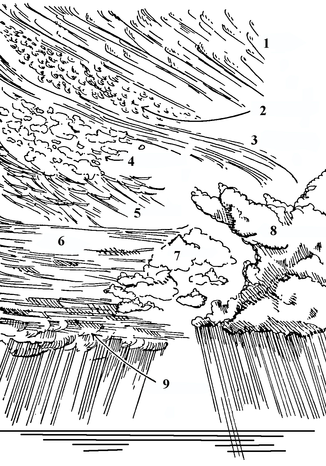
Schematic showing nine of the ten basic cloud types, numbered 1–9.